Ranger and Desert History
Ranger History – Black Rock Desert
History of the Black Rock Rangers
Traditionally, Rangers protect life and natural environments. They patrol an expanse of land and are members of one or more regional communities. Historically, Rangers were an alternative to local or federal law enforcement who patrolled vast, sparsely-populated territories (e.g., the Texas Rangers, Arizona Rangers, etc.).
In 1992, Danger Ranger founded the Black Rock Rangers. The Rangers served a search-and-rescue function in the Black Rock Desert before Burning Man had fences or streets, finding lost participants and returning them to their camps. This search-and-rescue function expanded to include life-safety issues in Black Rock City. Since the beginning of the event, the city has grown in size and population. In 1996, several accidents and incidents gave rise to concerns about community safety. One result was the establishment of new community standards in 1997 regarding citizen behavior (especially around motor vehicles and firearms). As the population of BRC grows larger and more diverse, the role of the Rangers is becoming more critical than ever before.
Today, the Black Rock Rangers are a broad cross-section of the Burning Man community who volunteer some of their time in the role of non-confrontational community mediators. They are empowered by the community and the Burning Man board to address safety concerns, mediate disputes, and resolve conflicts when they cannot be resolved by the persons involved. Rangers encourage a community of shared responsibility.
Responding to the ever-changing environment, Rangers address situations within their community that might otherwise require outside intervention. By encouraging and facilitating communication, Rangers promote awareness of potential hazards, from sunstroke to tent fires. Through their radios and shift briefings, Rangers carry the latest information to the citizens of Black Rock City. The Rangers’ primary concern is the safety of people, not property.
Ranger History – Black Rock Desert
The Black Rock Desert
The Playa
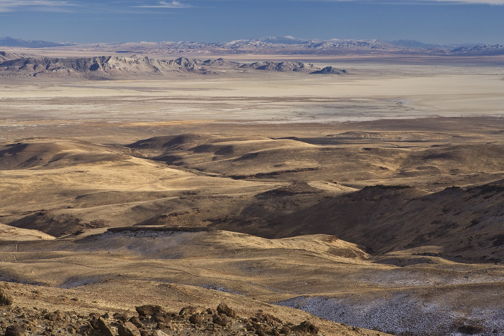
The Black Rock Desert is part of the Black Rock Desert/High Rock Canyon/Emigrant Trails National Conservation Area (NCA). This encompasses about 1.2 million acres of protected land, including the 11 designated wilderness areas that surround the NCA.
The playa, the vast expanse in which Burning Man is situated, is just one small part of the NCA. The Black Rock playa is about 32 miles long, stretching from Gerlach to the Black Rock. Because Black Rock City has grown tremendously in size since the inception of Burning Man, it can be challenging to see past the city into the desert. Rangers have traditionally been caretakers of the land in addition to the people who inhabit it. Knowing your way around the desert can be a real asset even in the middle of the City. This map shows some points of Rangerly interest in the Black Rock Desert.
General Orientation
The playa has a few entrance roads from Hwy 34, interestingly, all of which are marked and named for their distance from Bruno’s! There is a 3-mile entrance, which is closed to burner traffic during the event. Gate Road comes off of the 8-mile entrance to the playa. The 12-mile entrance (coming off of 7:30 and accessed from inside the city through Point 1) is used by vendors, law enforcement, and the DPW for BRC access. Ranger vehicles with a logo can also use this road if needed. All traffic through Point 1 requires a credential/wristband.
Black Rock City’s 12:00 generally points northeast. Facing north, the mountain range to your right (east) is the Jackson Range. On the playa itself, there is a “desert highway” that runs north-south along the east side called the East Track. This is one of the playa highways used in the dry months for getting around the desert. Great care should be taken when traveling on, and looking for, the East Track. Due to water runoff conditions, the Jackson Range side of the playa is usually the softest and easiest to get vehicles stuck in. Next to the East Track are railroad tracks. The East Track runs nearly parallel to the railroad in this part of the desert.
On the other side of the railroad is the legendary Jungo Road. Though it would seem that it would be a good idea to head towards the railroad tracks and Jungo Road if you are lost on the playa, that is most often not the case, as you are more likely to get your vehicle stuck in soft playa, and if you are going to Gerlach or Empire, it is definitely the long way around. Heading towards the Granites (see below) is a better course of action, as the playa generally is firmer on that side. Further, Jungo Road can be surprisingly dangerous if not driven with care; it is winding, bumpy, and tire-popping, and there have been many fatal accidents there.
The Granites
The range to your left (west) is the Granites and the road running along that side of the playa is called the West Track. Take your time when traveling onto the playa as you cross the West Track. It is an old wagon trail that the pioneers used and is a very historically significant rut.
The tallest peak in the area is located at the southern (Gerlach) end of the Granites and is called Granite Peak, with an elevation over 9,000 feet. Granite Peak cannot be seen from the town of Gerlach because of other smaller mountains in the way. There is another smaller mountain range that is north-by-northwest from the playa called the Calicos, named for its incredible swirled colors of orange, yellow, white, gold, etc.
Old Razorback
When looking at the Jackson Mountains (east), there is one mountain that stands out in the foreground. It comes to an even peak and is not attached to the rest of the range. This is Old Razorback, an excellent landmark indicating the 3:00 side of the City. At the base of Old Razorback, look for dark trees; they indicate the location of Frog Pond, one of the local hot springs. The north end of Old Razorback’s base is where Trego (another hot spring) is located.
The Black Rock
The namesake of the Black Rock Desert is actually one of the smaller landmarks in it. Look north, way out past the outer playa and you’ll see a range of mountains. In the foreground, there is a shorter, smaller, darker mountain. This is the Black Rock, a volcanic hill on the edge of the playa and home to Black Rock Hot Spring, a popular stopping point for emigrants headed west on Emigrant Trail during the late 19th century. In fact, next to the hot springs lie the remains of an old sheepherder’s wagon from times past.
Rendezvous Point
Rendezvous Point, where the Cassidy Mine Road from Soldier Meadows hits the playa, is about 3.3 miles north of the 12 Mile entrance at approximately 40.81685N, 119.22262W, or in degrees-minutes-seconds, 40° 49’ N, 119° 13’ 21” W.
Dog Camp
About a mile north of the 12 mile entrance (on the west side of the playa) is a popular camping area called Dog Camp. Years ago, Rangers used this site for the 4th of July ROM. Dog Camp is located about a mile north of the 12 mile playa entrance (on the west side of the playa) and has a hillside behind it with three horizontal purple stripes.
Steamboat Mountain
Further north than Dog Camp, also along the west side of the playa, is a free-standing hill called Steamboat Mountain. So named for its resemblance to an old steam-powered riverboat. It sits alongside Soldier Meadows Rd. in a saddle between the Black Rock playa and the Hualapai flat. There is a large hump at one end, followed by a long, flat top that then angles down. Steamboat Mountain looks different depending on where you are on the playa. Its apparent shape from any particular vantage point can help determine location and orientation on the playa.